


Si Nan National Park
อุทยานแห่งชาติศรีน่าน
อุทยานแห่งชาติศรีน่าน
Si Nan National Park
(อุทยานแห่งชาติศรีน่าน)
Nan
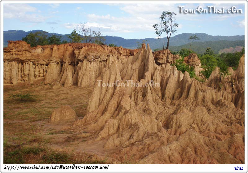
Si Nan National Park covers an area approximately 934 square kilometers in Wiang Sa, Na oi and Na Muen districts. The undulating mountain ranges line up from the north to the south, paralleling on both the western and eastern sides. They divide the area into the west and the east. Along the riverside are mixed deciduous forests while in the mountain ranges are mixed with hill evergreen forest, dried evergreen forest and pine forest. Rare wild animals are found here such as peacocks, leopards, panthers, bears, deer, wolves and Asiatic wild dogs. Moreover, many important wild animals are wild elephants, bantengs, and gaurs, which usually migrate in and out the frontier between Thailand and Laos.
Interesting Attractions in the National Park are as follows:
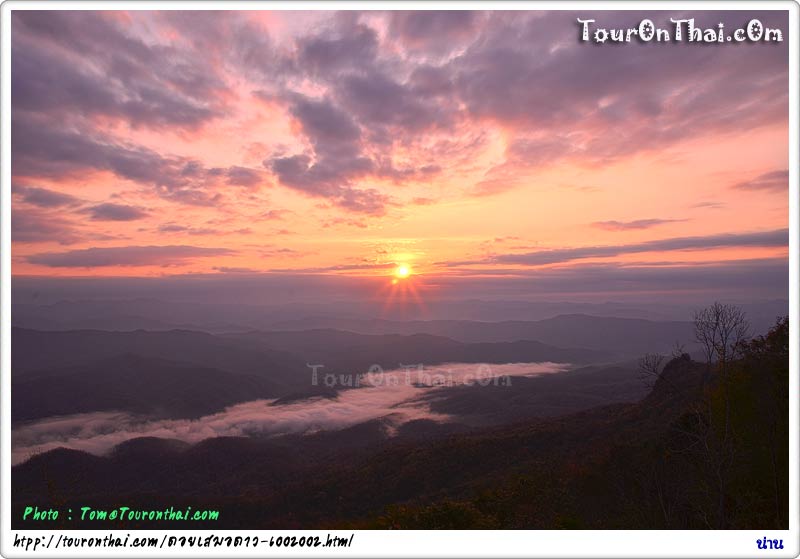
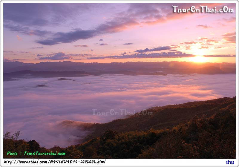
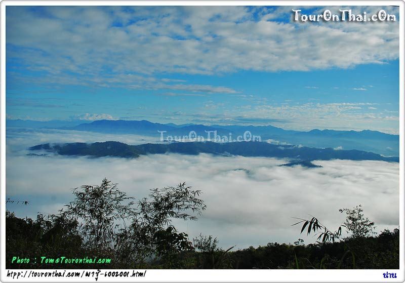
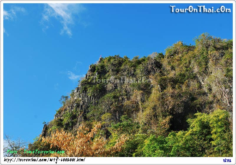
· Pha Chu Cliff is the steep mountain where its summit has the scenic view of Nan Mountains. It is the great spot to see sunrise which especially beautiful during the cool season with the sea of fog can be admired from the top. When the fog is disappearing, the summit conquerors can see the appealing curving of Nan River at the end of the forest. Pha Chu literally means “a cliff of secret loves,” there also is legend about three lovers who decided to kill themselves by jumping off this cliff to prove their true loves. Besides, Pha Chu is also famous as it has longest flag raising string in Thailand. With the 200-meter long, officers must sing national anthem for 12 times to raise the flag to the top. Those who are interested in climbing to the summit have to contact the national park office at the foot of Pha Chu before climbing. The round trip takes 1 hour with approximately 2 kilometers distance.
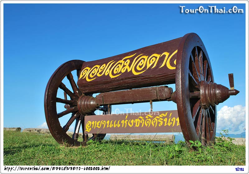
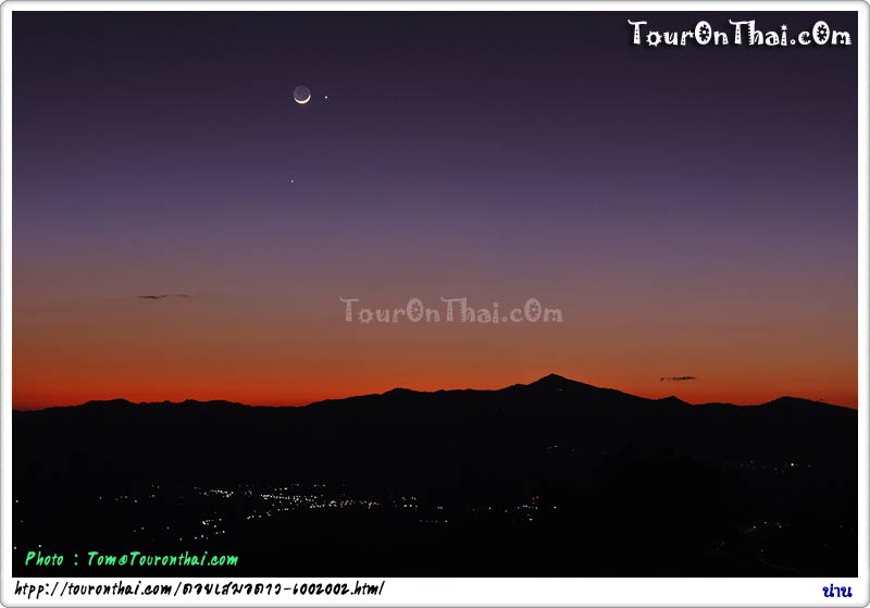
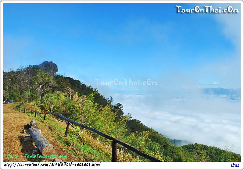
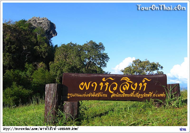
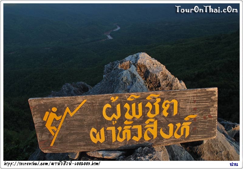
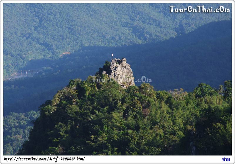
· Pha Hua Sing and Doi Samoe Dao These places are situated at Km. 16, the Na Noi – Pang Hai route. Pha Hua Sing, meaning a cliff with a strange shape similar to the head of a lion, is a viewpoint spot on the summit of the high cliff. It has 360° of beautiful mountainous scenery. At the spot, Doi Samor Dao also contains a wide terrace suitable for relaxation, star observation and sunset viewing. Visitors must contact National Park officers at the entrance which situated two kilometers away from the spot. On the route to the summit, visitors can enjoy Chan Pha, a unique mountain succulent shrubs, that appears along the way. Moreover, when the sky is clear, Na Noi and Wieng Sa districts, as well as, the Nan River can be viewed from the cliff.
· Kaeng Luang. 35 kilometers from Na Noi district, is the favorite islet for rafting spot. The route to Kaeng Luang is very difficult to travel because there are natural islets and cataracts caused by the stream flowing pass the rocks scattered in Nan River. During the season of a rushing torrent, there are echoes of water smashing against the rocks roaring all over the forest. During the dry season, rocks and white sandy beaches along the Nan River can be seen. Swimming should do in dry season only because the stream is too vigorous and dangerous in rainy season.
Accommodation and Facilities: There are bungalows and tents for rent but visitors must prepare their own food. For more information, please contact Si Nan National Park, P.O. Box 14, Si Sa Ket sub-district, Na Noi district, Nan 55150, tel. 0 5470 1106, 08 1224 0800 or the Department of National Parks, Wildlife and Flora, tel. 0 2562 0760 or www.dnp.go.th.
Opening hours: 6am-6pm
Admission: 100 baht for adults and 50 baht for children
Contact: 0 5473 1714, www.dnp.go.th
To get there: Si Nan National Park is 20 kilometers from Na Noi district. Proceed along Highway No. 1083, the Na Noi – Pang Hai route. There are viewpoint spots where visitors can enjoy scenery of the mountain ranges and the curving of Nan River flowing through the national park to Pak Nai district. Otherwise, travel by bus along the Bangkok – Nan route to Wiang Sa district and continue with the Wiang Sa – Na Noi – Na Muen Bus to the Ban Mai T-junction and rent a car further to the National Park. During February, the forest is especially beautiful by the change of color leaves.
(อุทยานแห่งชาติศรีน่าน)
Nan
Si Nan National Park covers an area approximately 934 square kilometers in Wiang Sa, Na oi and Na Muen districts. The undulating mountain ranges line up from the north to the south, paralleling on both the western and eastern sides. They divide the area into the west and the east. Along the riverside are mixed deciduous forests while in the mountain ranges are mixed with hill evergreen forest, dried evergreen forest and pine forest. Rare wild animals are found here such as peacocks, leopards, panthers, bears, deer, wolves and Asiatic wild dogs. Moreover, many important wild animals are wild elephants, bantengs, and gaurs, which usually migrate in and out the frontier between Thailand and Laos.
Interesting Attractions in the National Park are as follows:
· Pha Chu Cliff is the steep mountain where its summit has the scenic view of Nan Mountains. It is the great spot to see sunrise which especially beautiful during the cool season with the sea of fog can be admired from the top. When the fog is disappearing, the summit conquerors can see the appealing curving of Nan River at the end of the forest. Pha Chu literally means “a cliff of secret loves,” there also is legend about three lovers who decided to kill themselves by jumping off this cliff to prove their true loves. Besides, Pha Chu is also famous as it has longest flag raising string in Thailand. With the 200-meter long, officers must sing national anthem for 12 times to raise the flag to the top. Those who are interested in climbing to the summit have to contact the national park office at the foot of Pha Chu before climbing. The round trip takes 1 hour with approximately 2 kilometers distance.
· Pha Hua Sing and Doi Samoe Dao These places are situated at Km. 16, the Na Noi – Pang Hai route. Pha Hua Sing, meaning a cliff with a strange shape similar to the head of a lion, is a viewpoint spot on the summit of the high cliff. It has 360° of beautiful mountainous scenery. At the spot, Doi Samor Dao also contains a wide terrace suitable for relaxation, star observation and sunset viewing. Visitors must contact National Park officers at the entrance which situated two kilometers away from the spot. On the route to the summit, visitors can enjoy Chan Pha, a unique mountain succulent shrubs, that appears along the way. Moreover, when the sky is clear, Na Noi and Wieng Sa districts, as well as, the Nan River can be viewed from the cliff.
· Kaeng Luang. 35 kilometers from Na Noi district, is the favorite islet for rafting spot. The route to Kaeng Luang is very difficult to travel because there are natural islets and cataracts caused by the stream flowing pass the rocks scattered in Nan River. During the season of a rushing torrent, there are echoes of water smashing against the rocks roaring all over the forest. During the dry season, rocks and white sandy beaches along the Nan River can be seen. Swimming should do in dry season only because the stream is too vigorous and dangerous in rainy season.
Accommodation and Facilities: There are bungalows and tents for rent but visitors must prepare their own food. For more information, please contact Si Nan National Park, P.O. Box 14, Si Sa Ket sub-district, Na Noi district, Nan 55150, tel. 0 5470 1106, 08 1224 0800 or the Department of National Parks, Wildlife and Flora, tel. 0 2562 0760 or www.dnp.go.th.
Opening hours: 6am-6pm
Admission: 100 baht for adults and 50 baht for children
Contact: 0 5473 1714, www.dnp.go.th
To get there: Si Nan National Park is 20 kilometers from Na Noi district. Proceed along Highway No. 1083, the Na Noi – Pang Hai route. There are viewpoint spots where visitors can enjoy scenery of the mountain ranges and the curving of Nan River flowing through the national park to Pak Nai district. Otherwise, travel by bus along the Bangkok – Nan route to Wiang Sa district and continue with the Wiang Sa – Na Noi – Na Muen Bus to the Ban Mai T-junction and rent a car further to the National Park. During February, the forest is especially beautiful by the change of color leaves.
 |
0/0 จาก 0 รีวิว |
click for map of Si Nan National Park
Hotels near by Si Nan National Park
(อุทยานแห่งชาติศรีน่าน)
*note the distance is not an accurate transition on the road
Attractions near by Si Nan National Park
(อุทยานแห่งชาติศรีน่าน)
*note the distance is not an accurate transition on the road
Foods&Drinks near by Si Nan National Park
(อุทยานแห่งชาติศรีน่าน)
*we're collecting information*
send your favorite place click..
*note the distance is not an accurate transition on the road